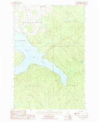
1986 Map of Paulette Brook
USGS Topo · Published 1986About this map
Long Lake dominates this northern Maine landscape, serving as a central hub for the townships of St Agatha, Madawaska, and Grand Isle. The interior terrain is defined by Mountain and a network of drainages including Paulette Brook and Cold Brook, which feed into the lake's eastern shore. Settlement is concentrated at Lavertue in the northern reaches, while the shoreline is marked by a Golf Course and several Gravel Pits, indicating the local extraction industry and recreational development characteristic of the mid-1980s. South of the main lake body, the land transitions into the surveyed townships of T 17 R 4 W E L S and T 17 R 3 W E L S, where smaller water bodies like Violette Pond and Mud Brook snake through the forested hills. This map captures the area before modern expansion, preserving the footprint of rural northern Aroostook County.
Find a feature on this map
15 named features on this map. Tap any name to fly to it.
Don’t see what you’re looking for? This feature index may not catch every label — zoom into the map to look around manually.
Map Details
Editions of this 1986 Paulette Brook Map
This is the sole edition of this map. No revisions or reprints were ever made.
Other maps of this area

1927 · Stockholm
USGS Topo · 1:48,000

1927 · Square Lake
USGS Topo · 1:48,000

1931 · Square Lake
USGS Topo · 1:62,500

1931 · Stockholm
USGS Topo · 1:62,500

1932 · Frenchville
USGS Topo · 1:48,000

1935 · Frenchville
USGS Topo · 1:62,500

1938 · Grand Isle
USGS Topo · 1:62,500

1940 · Grand Isle
USGS Topo · 1:62,500

1953 · Stockholm
USGS Topo · 1:62,500

1953 · Square Lake
USGS Topo · 1:62,500