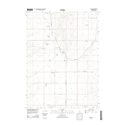
2013 Map of Pauline
USGS Topo · Published 2013About this map
Pauline and the surrounding Arbon Valley region define this high-altitude landscape in Power County, Idaho. The settlement pattern is largely dictated by the North-South corridor of the Arbon Valley Hwy, which threads between numerous deeply incised drainages such as West Fork Canyon, Knox Canyon, and Stump Hollow Canyon. Water management is central to life in this arid basin, as evidenced by features like the Pahawena Ditch, Waylett Spring, and the Cedar Well. The complex topography of the Bannock Cr and its tributaries, including W Fork Bannock Cr and Knox Cr, underscores the area's agricultural and pastoral reliance on seasonal flows and developed springs. Numerous local roads and lanes, such as England Rd and Lusk Loop, connect disparate ranch sites across the township and range divisions.
Find a feature on this map
38 named features on this map. Tap any name to fly to it.
Don’t see what you’re looking for? This feature index may not catch every label — zoom into the map to look around manually.
Map Details
Editions of this 2013 Pauline Map
This is the sole edition of this map. No revisions or reprints were ever made.
Other maps of this area

1938 · Pauline
USGS Topo · 1:48,000

1944 · Arbon
USGS Topo · 1:62,500

1954 · Pocatello
USGS Topo · 1:250,000

1958 · Pocatello
USGS Topo · 1:250,000

1968 · Dairy Creek
USGS Topo · 1:24,000

1968 · Clifton Creek
USGS Topo · 1:24,000

1968 · Bradley Mtn
USGS Topo · 1:24,000

1971 · Bannock Peak
USGS Topo · 1:24,000
1971 · Flatiron Hill
USGS Topo · 1:24,000
1971 · Sawmill Creek
USGS Topo · 1:24,000