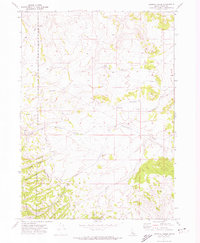
1971 Map of Sawmill Creek
USGS Topo · Published 1974About this map
The Fort Hall Indian Reservation Boundary cuts through the western edge of this landscape, marking a distinct administrative border against the rising slopes of the Deep Creek Mountains. This 1971 survey captures an area defined by its complex hydrology and high-elevation relief, where numerous named water sources like Fisher Spring and Corral Spring feed into systems such as Sawmill Creek and Rudeen Creek. The terrain is deeply incised by a series of prominent canyons, including Dry Canyon, Swede Canyon, and Porcupine Canyon. Transportation across this backcountry is limited to rugged routes like the Moonshine Trail and various Jeep Trails, highlighting the isolation of the area. The presence of Arbon Valley Road on the eastern margin suggests a transition toward the more accessible valley floor beyond the high ridges of Starlight.
Find a feature on this map
22 named features on this map. Tap any name to fly to it.
Don’t see what you’re looking for? This feature index may not catch every label — zoom into the map to look around manually.
Map Details
Editions of this 1971 Sawmill Creek Map
This is the sole edition of this map. No revisions or reprints were ever made.
Other maps of this area

1934 · American Falls
USGS Topo · 1:62,500

1934 · Michaud
USGS Topo · 1:62,500

1934 · Rockland
USGS Topo · 1:62,500

1936 · American Falls
USGS Topo · 1:62,500

1937 · Rockland
USGS Topo · 1:62,500

1937 · Michaud
USGS Topo · 1:62,500

1938 · Pauline
USGS Topo · 1:48,000

1944 · Arbon
USGS Topo · 1:62,500

1954 · Pocatello
USGS Topo · 1:250,000

1958 · Pocatello
USGS Topo · 1:250,000