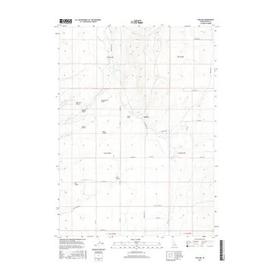
2017 Map of Pauline
USGS Topo · Published 2017About this map
Arbon Valley serves as the central corridor of this Power County landscape, where the settlement of Pauline sits along the Bannock Hwy. The terrain is defined by a series of significant drainage systems, including Bannock Cr and Knox Cr, which are fed by numerous canyons like West Fork Canyon and Stump Hollow Canyon. This 2017 survey illustrates a specialized water management network essential for high-desert ranching and agriculture, featuring the Pabawena Ditch, Rock Springs, and the isolated Cedar Well. The road network, including England Rd and Lusk Loop, follows the natural contours of the valley floor, connecting outlying springs such as Waylett Spring to the primary transportation routes. The map provides a clear view of the complex topography where the flat valley gives way to the intricate canyon lands of Dorys Canyon and Dry Canyon.
Find a feature on this map
38 named features on this map. Tap any name to fly to it.
Don’t see what you’re looking for? This feature index may not catch every label — zoom into the map to look around manually.
Map Details
Editions of this 2017 Pauline Map
This is the sole edition of this map. No revisions or reprints were ever made.
Other maps of this area

1938 · Pauline
USGS Topo · 1:48,000

1944 · Arbon
USGS Topo · 1:62,500

1954 · Pocatello
USGS Topo · 1:250,000

1958 · Pocatello
USGS Topo · 1:250,000

1968 · Dairy Creek
USGS Topo · 1:24,000

1968 · Clifton Creek
USGS Topo · 1:24,000

1968 · Bradley Mtn
USGS Topo · 1:24,000

1971 · Bannock Peak
USGS Topo · 1:24,000
1971 · Flatiron Hill
USGS Topo · 1:24,000
1971 · Sawmill Creek
USGS Topo · 1:24,000