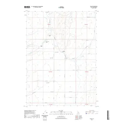
2020 Map of Pauline
USGS Topo · Published 2020About this map
Pauline and the surrounding high country of Power County are defined by a complex network of canyons and agricultural water management systems. The terrain is deeply incised by features such as West Fork Canyon, Stump Hollow Canyon, and Green Canyon, which channel seasonal runoff toward the primary drainage of Bannock Cr. Settlement is concentrated along the Arbon Valley Rd corridor, where the historic community of Arbon Valley and the small enclave at Rock Springs anchor the local geography. The map reveals the critical importance of water rights in this arid landscape, evidenced by the Pabawena Ditch and the presence of Waylett Spring, which support the ranching and farming operations that have sustained the region for generations.
Find a feature on this map
33 named features on this map. Tap any name to fly to it.
Don’t see what you’re looking for? This feature index may not catch every label — zoom into the map to look around manually.
Map Details
Editions of this 2020 Pauline Map
This is the sole edition of this map. No revisions or reprints were ever made.
Other maps of this area

1938 · Pauline
USGS Topo · 1:48,000

1944 · Arbon
USGS Topo · 1:62,500

1954 · Pocatello
USGS Topo · 1:250,000

1958 · Pocatello
USGS Topo · 1:250,000

1968 · Dairy Creek
USGS Topo · 1:24,000

1968 · Clifton Creek
USGS Topo · 1:24,000

1968 · Bradley Mtn
USGS Topo · 1:24,000

1971 · Bannock Peak
USGS Topo · 1:24,000
1971 · Flatiron Hill
USGS Topo · 1:24,000
1971 · Sawmill Creek
USGS Topo · 1:24,000