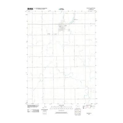
2010 Map of Paullina
USGS Topo · Published 2010About this map
Paullina serves as the central hub of this O'Brien County landscape, defined by a rigid grid of agricultural roads and a network of wandering waterways. The town's infrastructure is clearly marked, from the centrally located Paullina Post Office to the Paullina Municipal Airport situated to the northeast near Cole Creek. The map provides specific location data for genealogists and local historians, particularly the placement of West Prairie View Cemetery and Prairie View Cemetery situated just south of the main town site.
Find a feature on this map
27 named features on this map. Tap any name to fly to it.
Don’t see what you’re looking for? This feature index may not catch every label — zoom into the map to look around manually.
Map Details
Editions of this 2010 Paullina Map
This is the sole edition of this map. No revisions or reprints were ever made.
Other maps of this area

1954 · Fairmont
USGS Topo · 1:250,000

1954 · Fort Dodge
USGS Topo · 1:250,000

1957 · Fort Dodge
USGS Topo · 1:250,000

1958 · Fort Dodge
USGS Topo · 1:250,000

1958 · Fairmont
USGS Topo · 1:250,000

1964 · Sheldon SE
USGS Topo · 1:24,000

1964 · Primghar
USGS Topo · 1:24,000

1964 · Gaza
USGS Topo · 1:24,000

1969 · Cleghorn
USGS Topo · 1:24,000
1969 · Marcus
USGS Topo · 1:24,000