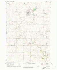
1971 Map of Paullina
USGS Topo · Published 1973About this map
Paullina serves as the central hub of this 1970s survey, situated along the Chicago and North Western railroad line. The landscape is defined by the winding paths of Mill Creek and its many tributaries, including Mud Creek and Whiskey Creek. Local recreation and infrastructure are prominent, with Mill Creek State Park featuring a large lake and golf course north of the town center, adjacent to the Paullina Municipal Airport. Genealogists and local historians will find the exact locations of the West Prairie View and Prairie View cemeteries, as well as the Oakdale Church in the southern portion of the quadrangle. The map reveals the agricultural and industrial character of the era through numerous gravel pits and the Radio Tower WT Compressor Station, illustrating the rural development of northwestern Iowa at this time.
Find a feature on this map
26 named features on this map. Tap any name to fly to it.
Don’t see what you’re looking for? This feature index may not catch every label — zoom into the map to look around manually.
Map Details
Editions of this 1971 Paullina Map
This is the sole edition of this map. No revisions or reprints were ever made.
Other maps of this area

1954 · Fairmont
USGS Topo · 1:250,000

1954 · Fort Dodge
USGS Topo · 1:250,000

1957 · Fort Dodge
USGS Topo · 1:250,000

1958 · Fort Dodge
USGS Topo · 1:250,000

1958 · Fairmont
USGS Topo · 1:250,000

1964 · Sheldon SE
USGS Topo · 1:24,000

1964 · Primghar
USGS Topo · 1:24,000

1964 · Gaza
USGS Topo · 1:24,000

1969 · Cleghorn
USGS Topo · 1:24,000
1969 · Marcus
USGS Topo · 1:24,000