
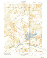
1915 Map of Paulsell
USGS Topo · Published 1915About this map
The Sierra Railway of California cuts through the northern reaches of this Stanislaus County landscape, passing through the small station of Paulsell. This 1915 survey reveals a complex water management system central to the region's agricultural development, dominated by the Modesto Reservoir and the flowing Tuolumne River at the southern boundary. The presence of the Modesto Ditch and Turlock Ditch illustrates the vital infrastructure supporting the central valley's irrigation needs during this era. Rural life is anchored by the Horrs School, while the winding course of Dry Creek meanders through the hills. This map provides a clear picture of the transition from the rolling hills to the engineered waterways that would come to define the area's economic geography.
Find a feature on this map
9 named features on this map. Tap any name to fly to it.
Don’t see what you’re looking for? This feature index may not catch every label — zoom into the map to look around manually.
Map Details
Editions of this 1915 Paulsell Map
2 editions found
Other maps of this area

1913 · Dickenson
USGS Topo · 1:31,680

1915 · Oakdale
USGS Topo · 1:31,680

1916 · Three Tree Flat
USGS Topo · 1:31,680

1916 · Montpellier
USGS Topo · 1:31,680

1916 · Cooperstown
USGS Topo · 1:31,680

1916 · Denair
USGS Topo · 1:31,680

1916 · Waterford
USGS Topo · 1:31,680

1916 · Copperopolis
USGS Topo · 1:62,500

1939 · Modesto East
USGS Topo · 1:62,500

1942 · Farmington
USGS Topo · 1:62,500