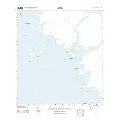
2012 Map of Pavilion Key
USGS Topo · Published 2012About this map
Ten Thousand Islands dominate this coastal survey of Monroe County, revealing the complex labyrinth of mangrove keys and tidal channels where the Florida peninsula meets the Gulf of Mexico. The geography is defined by a series of significant landforms including Pavilion Key, which serves as a primary navigational landmark with its Pavilion Key Light 10. Inlets such as Chatham Bend and Duck Rock Cove connect the open sea to interior waterways like the Huston River and Chatham River. This 2012 map illustrates the intricate coastal morphology of the region, featuring named points of interest such as Mormon Key, New Turkey Key, and Clam Point. The layout of these keys and bights offers a snapshot of the ever-shifting shoreline and the network of tidal flats and deep-water passages vital to coastal navigation in the Everglades region.
Find a feature on this map
26 named features on this map. Tap any name to fly to it.
Don’t see what you’re looking for? This feature index may not catch every label — zoom into the map to look around manually.
Map Details
Editions of this 2012 Pavilion Key Map
This is the sole edition of this map. No revisions or reprints were ever made.
Other maps of this area

1956 · Miami
USGS Topo · 1:250,000

1958 · Miami
USGS Topo · 1:250,000

1973 · Gator Hook Swamp
USGS Topo · 1:24,000

1973 · Pavilion Key
USGS Topo · 1:24,000
1973 · Plover Key
USGS Topo · 1:24,000

1973 · Lostmans River Ranger Station
USGS Topo · 1:24,000

1973 · Alligator Bay
USGS Topo · 1:24,000
1974 · Everglades City
USGS Topo · 1:24,000
1974 · Chokoloskee
USGS Topo · 1:24,000

1982 · Everglades City
USGS Topo · 1:100,000