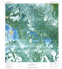
1974 Map of Chokoloskee
USGS Topo · Published 1976About this map
Chokoloskee Island serves as the focal point for this orthophotomap, showing the intricate relationship between human settlement and the aquatic wilderness of the Ten Thousand Islands in the mid-1970s. The small community of Chokoloskee is visible alongside nearby Plantation Island and a local Trailer Park, with a small Cem marking the historic presence of early residents. This survey documents the landscape shortly after the establishment of Everglades National Park, featuring the Wilderness Waterway and various transit corridors like the Turner River Canal and several airboat trails.
Find a feature on this map
32 named features on this map. Tap any name to fly to it.
Don’t see what you’re looking for? This feature index may not catch every label — zoom into the map to look around manually.
Map Details
Editions of this 1974 Chokoloskee Map
3 editions found
Other maps of this area

1956 · Miami
USGS Topo · 1:250,000

1958 · Miami
USGS Topo · 1:250,000

1972 · Weavers Station
USGS Topo · 1:24,000

1972 · Burns Lake
USGS Topo · 1:24,000

1972 · Ochopee
USGS Topo · 1:24,000

1973 · Gator Hook Swamp
USGS Topo · 1:24,000

1973 · Pavilion Key
USGS Topo · 1:24,000

1973 · Alligator Bay
USGS Topo · 1:24,000
1974 · Everglades City
USGS Topo · 1:24,000

1982 · Everglades City
USGS Topo · 1:100,000