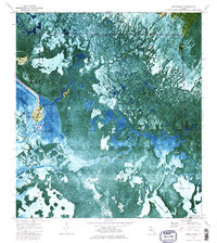
1974 Map of Chokoloskee
USGS Topo · Published 1984About this map
Chokoloskee Island and Plantation Island emerge as primary points of human habitation within this sprawling estuarine landscape in the mid-1970s. The map captures the meeting of land and water at the edge of Everglades National Park, where the Turner River and the Turner River Canal empty into the tangled mangrove systems of the Ten Thousand Islands. This orthophotomap format preserves a unique look at the coastal development occurring just north of the Chokoloskee Bay, showing the dense grid of a Trailer Park and a small Cem on the island. Further south, the map details the labyrinthine waterways of Cross Bays and Sunday Bay, reaching down to the Lopez area and its Lopez Campsite. Names like Hells Half Acre and Rabbit Key highlight the character of this remote Florida Gulf Coast environment.
Find a feature on this map
30 named features on this map. Tap any name to fly to it.
Don’t see what you’re looking for? This feature index may not catch every label — zoom into the map to look around manually.
Map Details
Editions of this 1974 Chokoloskee Map
3 editions found
Other maps of this area

1956 · Miami
USGS Topo · 1:250,000

1958 · Miami
USGS Topo · 1:250,000

1972 · Weavers Station
USGS Topo · 1:24,000

1972 · Burns Lake
USGS Topo · 1:24,000

1972 · Ochopee
USGS Topo · 1:24,000

1973 · Gator Hook Swamp
USGS Topo · 1:24,000

1973 · Pavilion Key
USGS Topo · 1:24,000

1973 · Alligator Bay
USGS Topo · 1:24,000
1974 · Everglades City
USGS Topo · 1:24,000
1974 · Chokoloskee
USGS Topo · 1:24,000