
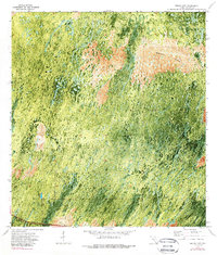
1972 Map of Burns Lake
USGS Topo · Published 1976About this map
Windmill Prairie and the dense cypress strands of southern Collier County dominate this orthophotomap, which utilizes aerial imagery from 1971 to document the landscape's hydrological and vegetative patterns. The southern edge of the quadrangle is defined by the historic Tamiami Trail, a critical infrastructure link that enabled the development of the Everglades region. North of this corridor, the land remains largely untamed, characterized by the light-toned expanse of the prairie and the eponymous Burns Lake. Traces of human presence are sparse, visible only in the survey-straight corridor of Burns Road and the established marker at BM 7. The map preserves the visual state of this wetland environment just as regional conservation efforts were beginning to reshape the management of the Big Cypress area, capturing the delicate transition between the open Concho region and the surrounding swamp.
Find a feature on this map
10 named features on this map. Tap any name to fly to it.
Don’t see what you’re looking for? This feature index may not catch every label — zoom into the map to look around manually.
Map Details
Editions of this 1972 Burns Lake Map
2 editions found
Other maps of this area

1956 · Miami
USGS Topo · 1:250,000

1956 · West Palm Beach
USGS Topo · 1:250,000

1957 · West Palm Beach
USGS Topo · 1:250,000

1958 · West Palm Beach
USGS Topo · 1:250,000

1958 · Miami
USGS Topo · 1:250,000

1959 · Deep Lake
USGS Topo · 1:24,000

1972 · Monroe Station NE
USGS Topo · 1:24,000

1972 · Ochopee
USGS Topo · 1:24,000

1973 · Gator Hook Swamp
USGS Topo · 1:24,000

1973 · Monroe Station
USGS Topo · 1:24,000