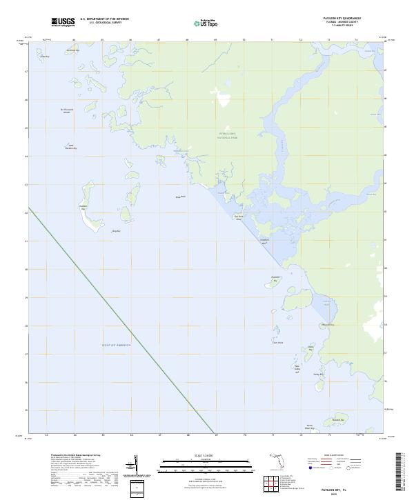
2025 Map of Pavilion Key
USGS Topo · Published 2025About this map
Ten Thousand Islands forms a complex labyrinth of mangrove keys and tidal channels along the southwestern coast of Florida, where the Gulf of America meets the vast wilderness of Everglades National Park. This coastal margin is defined by an intricate network of water bodies, including the Huston River and Chatham River, which snake through the island chain toward Huston Bay and Storter Bay. The map provides a detailed view of the remote keys that have long served as landmarks for mariners and coastal inhabitants, from the prominent Pavilion Key and Mormon Key to smaller features like Duck Rock and Snake Key. The lack of roads or inland settlements emphasizes the area's character as a maritime frontier, where land and water are inextricably linked and navigation depends entirely on the shifting passages of the mangrove estuaries.
Find a feature on this map
26 named features on this map. Tap any name to fly to it.
Don’t see what you’re looking for? This feature index may not catch every label — zoom into the map to look around manually.
Map Details
Editions of this 2025 Pavilion Key Map
This is the sole edition of this map. No revisions or reprints were ever made.
Other maps of this area

1956 · Miami
USGS Topo · 1:250,000

1958 · Miami
USGS Topo · 1:250,000

1973 · Gator Hook Swamp
USGS Topo · 1:24,000

1973 · Pavilion Key
USGS Topo · 1:24,000
1973 · Plover Key
USGS Topo · 1:24,000

1973 · Lostmans River Ranger Station
USGS Topo · 1:24,000

1973 · Alligator Bay
USGS Topo · 1:24,000
1974 · Everglades City
USGS Topo · 1:24,000
1974 · Chokoloskee
USGS Topo · 1:24,000

1982 · Everglades City
USGS Topo · 1:100,000