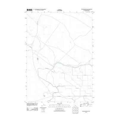
2012 Map of Pavillion Butte
USGS Topo · Published 2012About this map
Pavillion Butte stands as a prominent landmark in this section of Fremont County, anchoring a landscape shaped by both natural drainage and human irrigation. The presence of the Wyoming Canal and the Service Canal Rd indicates the importance of water management in this arid region, where moisture is moved across the terrain to support local ranching. The meandering course of Fivemile Cr and the seasonal nature of Water Rocks Draw further define the local topography. This 2012 survey reveals a network of rural roads with unique names such as Disneyland Rd, Teachers Rd, and Great Dane Way, suggesting a spread of modern rural homesteads and agricultural allotments. The northern reaches are more sparsely settled, marked primarily by Arapahoe Ranch Rd, reflecting the large-scale ranching operations typical of the Wyoming interior.
Find a feature on this map
16 named features on this map. Tap any name to fly to it.
Don’t see what you’re looking for? This feature index may not catch every label — zoom into the map to look around manually.
Map Details
Editions of this 2012 Pavillion Butte Map
This is the sole edition of this map. No revisions or reprints were ever made.
Other maps of this area

1950 · Pavillion
USGS Topo · 1:24,000

1950 · Pavillion Butte
USGS Topo · 1:24,000

1950 · Harris Bridge
USGS Topo · 1:24,000

1950 · Ocean Lake
USGS Topo · 1:24,000

1950 · Shotgun Butte
USGS Topo · 1:24,000

1951 · Eagle Point
USGS Topo · 1:24,000

1951 · Morton
USGS Topo · 1:24,000

1951 · Lookout Butte
USGS Topo · 1:24,000

1951 · Jenkins Mountain
USGS Topo · 1:24,000

1955 · Thermopolis
USGS Topo · 1:250,000