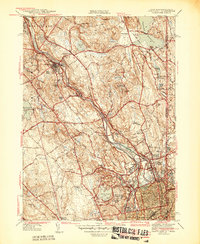
1944 Map of Pawtucket
USGS Topo · Published 1944About this map
The Blackstone River serves as the industrial and geographic spine of this Rhode Island landscape, with a dense network of mill towns and rail infrastructure defining the mid-1940s economy. The New York New Haven and Hartford railroad tracks follow the river's winding path, connecting settlements like Manville, Albion, and Lonsdale. Urban growth is concentrated in the south around Central Falls and Pawtucket, while the central portion reveals the sprawling Lincoln Woods Reservation and the Cistercian Monastery. Local history is deeply embedded in the terrain, from the Moshassuck Cem to the family-named landmarks like Whipple Hill and Sayles Hill. The map also captures the transition across state lines into Massachusetts, featuring the Pawtucket Reservoirs and the prominent Diamond Hill overlooking the northern valleys.
Find a feature on this map
71 named features on this map. Tap any name to fly to it.
Don’t see what you’re looking for? This feature index may not catch every label — zoom into the map to look around manually.
Map Details
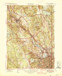
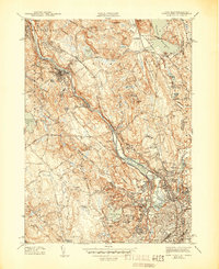
Editions of this 1944 Pawtucket Map
3 editions found
Other maps of this area

1886 · Blackstone
USGS Topo · 1:62,500

1887 · Franklin
USGS Topo · 1:62,500

1887 · Providence
USGS Topo · 1:62,500

1889 · Providence
USGS Topo · 1:62,500

1889 · Blackstone
USGS Topo · 1:62,500

1889 · Franklin
USGS Topo · 1:62,500

1889 · Burrillville
USGS Topo · 1:62,500

1893 · Franklin
USGS Topo · 1:62,500

1893 · Blackstone
USGS Topo · 1:62,500

1894 · Burrillville
USGS Topo · 1:62,500