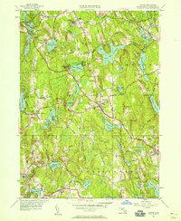
1950 Map of Paxton
USGS Topo · Published 1958About this map
Asnebumskit Hill and its surrounding ridgelines dominate this central Massachusetts landscape, providing the high-ground context for the water management systems of Worcester County. The mapping reveals a complex network of reservoirs and ponds, including Pine Hill Reservoir and the multi-staged Holden Reservoirs, which illustrate the region's historical reliance on localized water storage. In the industrial pockets to the south, Upper Wire Village and Lower Wire Village mark the manufacturing heritage of Spencer, while the Boston and Maine RR (Abandoned) traces a northern arc through Jefferson and Rutland. Civic life and social history are anchored by institutions like the Veterans Hospital and the State Sanitorium, alongside numerous family-named landmarks and crossroads such as Proctors Corner and Tafts Corner that define the mid-century township boundaries.
Find a feature on this map
82 named features on this map. Tap any name to fly to it.
Don’t see what you’re looking for? This feature index may not catch every label — zoom into the map to look around manually.
Map Details
Editions of this 1950 Paxton Map
2 editions found
Other maps of this area

1885 · Worcester
USGS Topo · 1:62,500

1886 · Worcester
USGS Topo · 1:62,500

1887 · Brookfield
USGS Topo · 1:62,500

1887 · Barre
USGS Topo · 1:62,500

1889 · Webster
USGS Topo · 1:62,500

1889 · Barre
USGS Topo · 1:62,500

1890 · Brookfield
USGS Topo · 1:62,500

1892 · Webster
USGS Topo · 1:62,500

1892 · Worcester
USGS Topo · 1:62,500

1893 · Brookfield
USGS Topo · 1:62,500