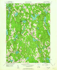
1950 Map of Paxton
USGS Topo · Published 1963About this map
Paxton and its neighboring Worcester County townships appear at mid-century as a landscape defined by industrial history and institutional sprawl. The southern reaches of the map highlight the textile legacy of Spencer, specifically at Upper Wire Village and Lower Wire Village, where the settlement pattern follows the local water power. In the north, the massive footprints of the Veterans Hospital and the State Sanitorium in Rutland dominate the high ground near Barrack Hill.
Find a feature on this map
105 named features on this map. Tap any name to fly to it.
Don’t see what you’re looking for? This feature index may not catch every label — zoom into the map to look around manually.
Map Details
Editions of this 1950 Paxton Map
2 editions found
Other maps of this area

1885 · Worcester
USGS Topo · 1:62,500

1886 · Worcester
USGS Topo · 1:62,500

1887 · Brookfield
USGS Topo · 1:62,500

1887 · Barre
USGS Topo · 1:62,500

1889 · Webster
USGS Topo · 1:62,500

1889 · Barre
USGS Topo · 1:62,500

1890 · Brookfield
USGS Topo · 1:62,500

1892 · Webster
USGS Topo · 1:62,500

1892 · Worcester
USGS Topo · 1:62,500

1893 · Brookfield
USGS Topo · 1:62,500