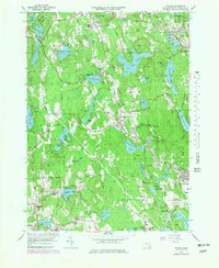
1965 Map of Paxton
USGS Topo · Published 1979About this map
The town of Paxton serves as a central hub in this mid-century survey of Worcester County, where the transition from agricultural landscapes to suburban and institutional land use is clearly visible. Significant regional infrastructure defines the eastern edge of the map, including the Worcester Municipal Airport and the Boston and Maine Railroad passing through Jefferson. The landscape is notably dotted with several municipal water supplies, such as the Kettle Brook Reservoir No. 1 and Kendall Reservoir, which highlight the importance of the local watershed to the surrounding urban centers.
Find a feature on this map
108 named features on this map. Tap any name to fly to it.
Don’t see what you’re looking for? This feature index may not catch every label — zoom into the map to look around manually.
Map Details
Editions of this 1965 Paxton Map
2 editions found
Other maps of this area

1885 · Worcester
USGS Topo · 1:62,500

1886 · Worcester
USGS Topo · 1:62,500

1887 · Brookfield
USGS Topo · 1:62,500

1887 · Barre
USGS Topo · 1:62,500

1889 · Webster
USGS Topo · 1:62,500

1889 · Barre
USGS Topo · 1:62,500

1890 · Brookfield
USGS Topo · 1:62,500

1892 · Webster
USGS Topo · 1:62,500

1892 · Worcester
USGS Topo · 1:62,500

1893 · Brookfield
USGS Topo · 1:62,500