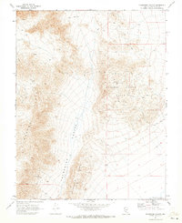
1970 Map of Paymaster Canyon
USGS Topo · Published 1973About this map
Mining and topography dominate this 1970 field-checked survey of Esmeralda County. The landscape is defined by the massive Paymaster Canyon corridor, which separates the Weepah Hills from the General Thomas Hills. In the high ground, the General Thomas Mine and the Paymaster Mine indicate the region's enduring mineral interest, while scattered prospects suggest widespread exploration throughout the mid-20th century. The presence of a Corral and a Dry Well highlights the practical challenges of working this arid terrain.
Find a feature on this map
16 named features on this map. Tap any name to fly to it.
Don’t see what you’re looking for? This feature index may not catch every label — zoom into the map to look around manually.
Map Details
Editions of this 1970 Paymaster Canyon Map
This is the sole edition of this map. No revisions or reprints were ever made.
Other maps of this area

1898 · Silver Peak
USGS Topo · 1:125,000

1900 · Silver Peak
USGS Topo · 1:125,000

1907 · Tonopah
USGS Topo · 1:250,000

1908 · Lida
USGS Topo · 1:250,000

1908 · Tonopah
USGS Topo · 1:250,000

1913 · Lida
USGS Topo · 1:250,000

1945 · Goldfield
USGS Topo · 1:125,000

1954 · Goldfield
USGS Topo · 1:250,000

1955 · Goldfield
USGS Topo · 1:250,000

1956 · Tonopah
USGS Topo · 1:250,000