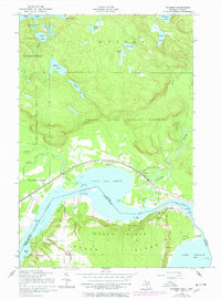
1951 Map of Payment
USGS Topo · Published 1978About this map
The international waters of the Marys River and Little Lake George separate the rugged Ontario highlands from the northern reaches of Sugar Island in Michigan. This mid-century survey captures the complex geography of the borderlands, where the Canadian Pacific railroad tracks skirt the northern shoreline through the Garden River Indian Reserve. The settlement of Garden River serves as a focal point for rail and river activity, while further inland, a dense network of lakes such as Surette Lake and Mabel Lake occupy the interior terrain of Duncan.
Find a feature on this map
48 named features on this map. Tap any name to fly to it.
Don’t see what you’re looking for? This feature index may not catch every label — zoom into the map to look around manually.
Map Details
Editions of this 1951 Payment Map
2 editions found
Other maps of this area

1913 · Sault Sainte Marie
USGS Topo · 1:62,500

1919 · Neebish
USGS Topo · 1:62,500

1941 · Neebish
USGS Topo · 1:63,360

1941 · Sault Sainte Marie
USGS Topo · 1:63,360

1951 · Baie De Wasai
USGS Topo · 1:24,000

1951 · Sault Ste. Marie
USGS Topo · 1:62,500

1951 · Sault Ste. Marie South
USGS Topo · 1:24,000

1951 · Payment
USGS Topo · 1:24,000

1951 · Lake George
USGS Topo · 1:62,500

1954 · Sault Sainte Marie
USGS Topo · 1:250,000