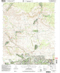
2004 Map of Payson North
USGS Topo · Published 2006About this map
Tonto National Forest land dominates this 2004 survey, which highlights the transition from the high Mogollon Rim country down toward the northern reaches of Payson. The landscape is defined by the Verde River, which is marked by several named crossings such as First Crossing and Water Wheel. This area serves as a focal point for dispersed residential developments including Beaver Valley Estates, Whispering Pines, and Geronimo Estates, many of which are situated along the river's path or tucked into canyons like Spring Canyon.
Find a feature on this map
82 named features on this map. Tap any name to fly to it.
Don’t see what you’re looking for? This feature index may not catch every label — zoom into the map to look around manually.
Map Details
Editions of this 2004 Payson North Map
This is the sole edition of this map. No revisions or reprints were ever made.
Other maps of this area

1887 · Verde
USGS Topo · 1:250,000

1892 · Verde
USGS Topo · 1:250,000

1934 · Pine
USGS Topo · 1:62,500

1934 · Promontory Butte
USGS Topo · 1:62,500

1936 · Payson
USGS Topo · 1:48,000

1937 · Diamond Butte
USGS Topo · 1:48,000

1939 · Promontory Butte
USGS Topo · 1:62,500

1940 · Pine
USGS Topo · 1:62,500

1942 · Payson
USGS Topo · 1:62,500

1943 · Diamond Butte
USGS Topo · 1:62,500