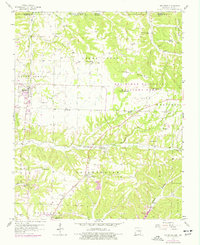
1958 Map of Pea Ridge
USGS Topo · Published 1977About this map
Pea Ridge National Military Park preserves a significant Civil War landscape across the northern Arkansas borderlands, where the Pea Ridge Battlefield and the historic Elkhorn Tavern stand as key landmarks. This survey illustrates a rural landscape transitioning during the mid-20th century, where the St Louis San Francisco railroad cuts a path through the rolling hills toward Avoca. Local family history is preserved in numerous burial grounds such as Banks Cem, Ford Cem, and Buttram Cem, while the town of Pea Ridge shows its early footprint before later regional growth. To the south, the emergence of Beaver Lake and the presence of Rogers Municipal Airport (Carter Field) reflect the modernization of transport and infrastructure in Benton County.
Find a feature on this map
52 named features on this map. Tap any name to fly to it.
Don’t see what you’re looking for? This feature index may not catch every label — zoom into the map to look around manually.
Map Details
Editions of this 1958 Pea Ridge Map
4 editions found

Other maps of this area

1899 · Fayetteville
USGS Topo · 1:125,000

1900 · Eureka Springs
USGS Topo · 1:125,000

1901 · Eureka Springs
USGS Topo · 1:125,000

1901 · Fayetteville
USGS Topo · 1:125,000

1904 · Fayetteville
USGS Topo · 1:125,000

1937 · Cassville
USGS Topo · 1:48,000

1941 · Rocky Comfort
USGS Topo · 1:62,500

1943 · Rocky Comfort
USGS Topo · 1:62,500

1944 · Cassville
USGS Topo · 1:62,500

1945 · Harrison
USGS Topo · 1:250,000