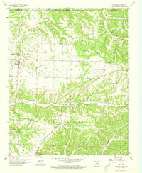
1958 Map of Pea Ridge
USGS Topo · Published 1973About this map
Pea Ridge Battlefield and its commemorative landscape dominate the center of this survey, including the site of the historic Elkhorn Tavern near Elkhorn Mountain. The map details the border between Arkansas and Missouri, showing the complex terrain of Roller Ridge and the deep cuts of Walnut Hollow and Sugar Creek. Settlement patterns are concentrated around the town of Pea Ridge and the village of Avoca, which is linked to the regional economy via the St Louis San Francisco railroad line. This 1950s record is particularly valuable for its density of small community landmarks, from rural sanctuaries like Tucks Chapel and Freedom Ch to family-named burying grounds such as Buttram Cem and Ford Cem. The presence of the Twelve Corners community and numerous springs like Winton Spring further illustrates the established rural life in Benton County during the mid-century.
Find a feature on this map
47 named features on this map. Tap any name to fly to it.
Don’t see what you’re looking for? This feature index may not catch every label — zoom into the map to look around manually.
Map Details
Editions of this 1958 Pea Ridge Map
4 editions found

Other maps of this area

1899 · Fayetteville
USGS Topo · 1:125,000

1900 · Eureka Springs
USGS Topo · 1:125,000

1901 · Eureka Springs
USGS Topo · 1:125,000

1901 · Fayetteville
USGS Topo · 1:125,000

1904 · Fayetteville
USGS Topo · 1:125,000

1937 · Cassville
USGS Topo · 1:48,000

1941 · Rocky Comfort
USGS Topo · 1:62,500

1943 · Rocky Comfort
USGS Topo · 1:62,500

1944 · Cassville
USGS Topo · 1:62,500

1945 · Harrison
USGS Topo · 1:250,000