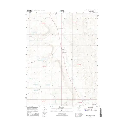
2015 Map of Peach Orchard Flat
USGS Topo · Published 2015About this map
Peach Orchard Flat and the surrounding high desert plateau of Carbon County define this landscape, where early 21st-century infrastructure meets a geography shaped by drainage systems. The area is characterized by numerous water management structures designed for the arid environment, including the Little Robber Detention Dam and Detention Reservoir 1492 Number 2. These features, along with several others like Detention Dam 1592 Number 1, suggest a managed approach to the seasonal flows of local waterways such as Muddy Cr and Cherokee Cr.
Find a feature on this map
30 named features on this map. Tap any name to fly to it.
Don’t see what you’re looking for? This feature index may not catch every label — zoom into the map to look around manually.
Map Details
Editions of this 2015 Peach Orchard Flat Map
This is the sole edition of this map. No revisions or reprints were ever made.
Other maps of this area

1954 · Rawlins
USGS Topo · 1:250,000

1957 · Baggs
USGS Topo · 1:62,500

1957 · Doty Mountain
USGS Topo · 1:62,500

1958 · Rawlins
USGS Topo · 1:250,000

1962 · Rawlins
USGS Topo · 1:250,000

1967 · Rawlins
USGS Topo · 1:250,000

1970 · Mexican Flats
USGS Topo · 1:24,000
1970 · Flat Top Mountain
USGS Topo · 1:24,000
1970 · Poison Basin
USGS Topo · 1:24,000
1975 · Baggs NW
USGS Topo · 1:24,000