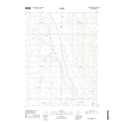
2017 Map of Peach Orchard Flat
USGS Topo · Published 2017About this map
Peach Orchard Flat dominates this high-plains landscape in Carbon County, where a complex network of ephemeral water management defines the arid terrain. The map reveals an extensive system of numbered water controls, including Detention Reservoir 1492 Number 2 and several others such as Detention Dam 1592 Number 1 and Detention Dam 1492 Number 6, which are essential for livestock and land management in the Wyoming interior. This infrastructure is woven between prominent geological formations like The Bluffs and deep incisions such as Robber's Gulch and Little Robbers Gulch. Seasonal drainage patterns are traced through Muddy Cr, Cherokee Cr, and several named draws including Wild Horse Draw and Pines Draw. Remote access is facilitated by primitive routes like Big Robber Gulch Rd and Sandcreek Rd, which serve this sparsely settled range land.
Find a feature on this map
28 named features on this map. Tap any name to fly to it.
Don’t see what you’re looking for? This feature index may not catch every label — zoom into the map to look around manually.
Map Details
Editions of this 2017 Peach Orchard Flat Map
This is the sole edition of this map. No revisions or reprints were ever made.
Other maps of this area

1954 · Rawlins
USGS Topo · 1:250,000

1957 · Baggs
USGS Topo · 1:62,500

1957 · Doty Mountain
USGS Topo · 1:62,500

1958 · Rawlins
USGS Topo · 1:250,000

1962 · Rawlins
USGS Topo · 1:250,000

1967 · Rawlins
USGS Topo · 1:250,000

1970 · Mexican Flats
USGS Topo · 1:24,000
1970 · Flat Top Mountain
USGS Topo · 1:24,000
1970 · Poison Basin
USGS Topo · 1:24,000
1975 · Baggs NW
USGS Topo · 1:24,000