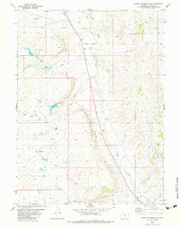
1982 Map of Peach Orchard Flat
USGS Topo · Published 1983About this map
Peach Orchard Flat dominates the central landscape of this Carbon County survey, a high-desert expanse characterized by ephemeral drainages and rising terrain. The topographic detail highlights The Bluffs and the winding course of Muddy Creek, illustrating the drainage patterns that define this arid region. The late 20th-century economic activity is evident through the widespread distribution of energy infrastructure, including numerous labeled Gas Wells and a prominent north-south Pipeline. Sparse transportation routes consist primarily of primitive paths like the Pines Trail and various Jeep Trails, suggesting a landscape used more for industrial extraction and ranching than for dense settlement. Named waterways such as Cherokee Creek and Little Robbers Gulch provide important landmarks for local history and geographic study in this portion of southern Wyoming.
Find a feature on this map
15 named features on this map. Tap any name to fly to it.
Don’t see what you’re looking for? This feature index may not catch every label — zoom into the map to look around manually.
Map Details
Editions of this 1982 Peach Orchard Flat Map
This is the sole edition of this map. No revisions or reprints were ever made.
Other maps of this area

1954 · Rawlins
USGS Topo · 1:250,000

1957 · Baggs
USGS Topo · 1:62,500

1957 · Doty Mountain
USGS Topo · 1:62,500

1958 · Rawlins
USGS Topo · 1:250,000

1962 · Rawlins
USGS Topo · 1:250,000

1967 · Rawlins
USGS Topo · 1:250,000

1970 · Mexican Flats
USGS Topo · 1:24,000
1970 · Flat Top Mountain
USGS Topo · 1:24,000
1970 · Poison Basin
USGS Topo · 1:24,000
1975 · Baggs NW
USGS Topo · 1:24,000