
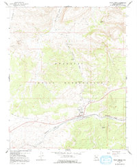
1967 Map of Peach Springs
USGS Topo · Published 1970About this map
The Hualapai Indian Reservation serves as the focal point of this 1960s study, centering on the community of Peach Springs and its more isolated counterpart, Lower Peach Springs. The landscape is defined by the logistics of the high desert, where the Atchison Topeka and Santa Fe railroad runs parallel to the iconic Route 66, threading through the deep cuts of Yampai Canyon. This transportation corridor was the lifeblood of the region, supported by infrastructure like the Peach Springs Airport and a hilltop Radio Tower.
Find a feature on this map
21 named features on this map. Tap any name to fly to it.
Don’t see what you’re looking for? This feature index may not catch every label — zoom into the map to look around manually.
Map Details
Editions of this 1967 Peach Springs Map
2 editions found
Other maps of this area

1886 · Diamond Creek
USGS Topo · 1:250,000

1892 · Diamond Creek
USGS Topo · 1:250,000

1948 · Williams
USGS Topo · 1:250,000

1954 · Williams
USGS Topo · 1:250,000

1956 · Williams
USGS Topo · 1:250,000

1960 · Williams
USGS Topo · 1:250,000

1961 · Williams
USGS Topo · 1:250,000
1967 · Milkweed Canyon SE
USGS Topo · 1:24,000
1967 · Peach Springs Canyon
USGS Topo · 1:24,000
1967 · Peach Springs NE
USGS Topo · 1:24,000