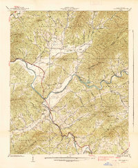
1938 Map of Peachtree
USGS Topo · Published 1938About this map
The Hiwassee River and Brasstown Creek form the central arteries of this Appalachian landscape, where industrial infrastructure and traditional community life meet. In the late 1930s, the region was undergoing modernization, evidenced by the Andrews Dam on the Hiwassee and the Southern States Power Co facility near Peachtree. Despite these utility developments, the map reveals a deeply rooted rural social structure defined by numerous country churches such as Hickory Stand Ch and Maggie Chapel, and the notable Campbell Folk School near the Clay and Cherokee county line.
Find a feature on this map
92 named features on this map. Tap any name to fly to it.
Don’t see what you’re looking for? This feature index may not catch every label — zoom into the map to look around manually.
Map Details
Editions of this 1938 Peachtree Map
This is the sole edition of this map. No revisions or reprints were ever made.
Other maps of this area

1886 · Dahlonega
USGS Topo · 1:125,000

1888 · Ellijay
USGS Topo · 1:125,000

1892 · Dahlonega
USGS Topo · 1:125,000

1892 · Ellijay
USGS Topo · 1:125,000

1893 · Murphy
USGS Topo · 1:125,000

1896 · Dahlonega
USGS Topo · 1:125,000

1898 · Ellijay
USGS Topo · 1:125,000

1903 · Dahlonega
USGS Topo · 1:125,000

1911 · Ellijay
USGS Topo · 1:125,000

1914 · Murphy
USGS Topo · 1:125,000