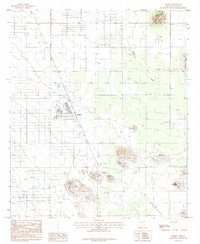
1985 Map of Pearce
USGS Topo · Published 1985About this map
Pearce and the nearby residential development of Sunsites anchor this landscape, where the legacy of Arizona mining intersects with modern retirement-era planning. The map reveals a distinct contrast between the older mining operations at Pearce Hill and the structured layout of the Golf Course and several Trailer Park areas in Sunsites. For local historians, the presence of the Old RR Grade and numerous Mine Shafts points to the area's industrial past, while the local Cem remains a vital link for genealogical research. Prominent landmarks such as Six Mile Hill, Township Butte, and the Three Sisters Buttes dominate the horizons, while Turkey Creek provides a natural drain through the valley. The map also documents utilitarian features like the Sewage Disposal Ponds and a Tailings Pond, marking the footprint of both community growth and mineral extraction.
Find a feature on this map
22 named features on this map. Tap any name to fly to it.
Don’t see what you’re looking for? This feature index may not catch every label — zoom into the map to look around manually.
Map Details
Editions of this 1985 Pearce Map
This is the sole edition of this map. No revisions or reprints were ever made.
Other maps of this area

1916 · Pearce
USGS Topo · 1:125,000

1922 · Willcox
USGS Topo · 1:125,000

1926 · Light
USGS Topo · 1:62,500

1926 · Courtland
USGS Topo · 1:62,500

1943 · Dos Cabezas
USGS Topo · 1:62,500

1943 · Cochise
USGS Topo · 1:62,500

1954 · Silver City
USGS Topo · 1:250,000

1955 · Douglas
USGS Topo · 1:250,000

1957 · Dos Cabezas
USGS Topo · 1:62,500

1958 · Silver City
USGS Topo · 1:250,000