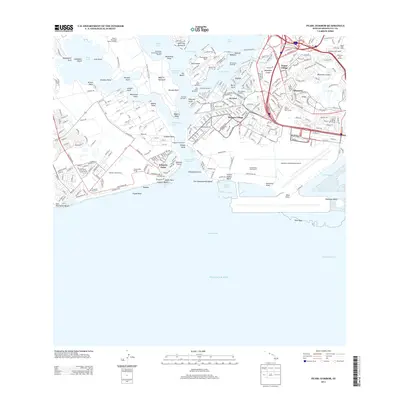
2013 Map of Pearl Harbor
USGS Topo · Published 2013About this map
Ford Island sits at the center of this 2013 survey of the naval and aviation complex of Pearl Harbor, surrounded by the three lochs and the North Channel. The map documents the extensive military and transportation infrastructure of the era, from the USS Arizona Memorial to the massive runway networks of the Honolulu International Airport and Ford Island NALF. Industrial features like Dry Dock Number 1 and the Beckoning Point Deperming Facility stand alongside residential developments such as Foster Village and Hickam Village. To the east, the volcanic geography of Makalapa Crater and Salt Lake contrasts with the engineered coastline of Ke'ehi Lagoon. The map also captures specialized facilities including the Honolulu Observatory and the Puuloa Rifle Range, illustrating the dense layering of defense, civic, and scientific interests on the Waipi'o Peninsula and surrounding shores.
Find a feature on this map
98 named features on this map. Tap any name to fly to it.
Don’t see what you’re looking for? This feature index may not catch every label — zoom into the map to look around manually.
Map Details
Editions of this 2013 Pearl Harbor Map
This is the sole edition of this map. No revisions or reprints were ever made.
Other maps of this area

1953 · Schofield Barracks
USGS Topo · 1:24,000

1953 · Honolulu
USGS Topo · 1:24,000

1953 · Ewa
USGS Topo · 1:24,000

1953 · Puuloa
USGS Topo · 1:24,000

1954 · Oahu
USGS Topo · 1:250,000

1954 · Kaneohe
USGS Topo · 1:24,000

1954 · Waipahu
USGS Topo · 1:24,000

1959 · Kaneohe
USGS Topo · 1:24,000

1959 · Honolulu
USGS Topo · 1:24,000

1959 · Waipahu
USGS Topo · 1:24,000