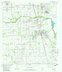
1982 Map of Pearland
USGS Topo · Published 1983About this map
Pearland serves as the central hub of this 1980s landscape, showing a period of transition where residential expansion meets established industrial and agricultural roots. The city is bisected by the Atchison Topeka and Santa Fe railroad, which runs parallel to a corridor of cemeteries and schools, including South Park Cemetery and the Jr High Sch. To the south, the economy is anchored by the Hastings Oil Field and Manvel Oil Field, with numerous wells and pipelines dotting the terrain near Mustang Bayou and Cowart Creek.
Find a feature on this map
44 named features on this map. Tap any name to fly to it.
Don’t see what you’re looking for? This feature index may not catch every label — zoom into the map to look around manually.
Map Details
Editions of this 1982 Pearland Map
This is the sole edition of this map. No revisions or reprints were ever made.
Other maps of this area

1915 · Bellaire
USGS Topo · 1:24,000

1915 · Park Place
USGS Topo · 1:24,000

1915 · Deepwater
USGS Topo · 1:24,000

1916 · Genoa
USGS Topo · 1:24,000

1919 · Deepwater
USGS Topo · 1:31,680

1920 · Genoa
USGS Topo · 1:31,680

1920 · Mykawa
USGS Topo · 1:31,680

1920 · Almeda
USGS Topo · 1:31,680

1921 · Bellaire
USGS Topo · 1:31,680

1922 · Park Place
USGS Topo · 1:31,680