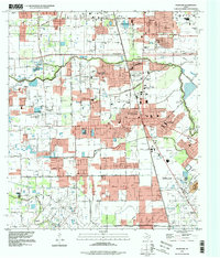
1995 Map of Pearland
USGS Topo · Published 1998About this map
Pearland and its surrounding communities in both Harris and Brazoria counties appear here during a period of significant suburban expansion in the mid-1990s. The landscape is a mix of established residential grids and remaining open space, defined by a complex drainage network including Clear Creek, Hickory Slough, and Marys Creek. Transport infrastructure is prominent, featuring the Houston Belt and Terminal RR and specialized aviation sites like Skyway Manor Airport and the Pearland Heliport.
Find a feature on this map
45 named features on this map. Tap any name to fly to it.
Don’t see what you’re looking for? This feature index may not catch every label — zoom into the map to look around manually.
Map Details
Editions of this 1995 Pearland Map
This is the sole edition of this map. No revisions or reprints were ever made.
Other maps of this area

1915 · Bellaire
USGS Topo · 1:24,000

1915 · Park Place
USGS Topo · 1:24,000

1915 · Deepwater
USGS Topo · 1:24,000

1916 · Genoa
USGS Topo · 1:24,000

1919 · Deepwater
USGS Topo · 1:31,680

1920 · Genoa
USGS Topo · 1:31,680

1920 · Mykawa
USGS Topo · 1:31,680

1920 · Almeda
USGS Topo · 1:31,680

1921 · Bellaire
USGS Topo · 1:31,680

1922 · Park Place
USGS Topo · 1:31,680