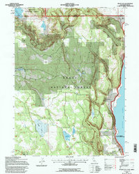
1993 Map of Pease Flat
USGS Topo · Published 1997About this map
Goose Lake dominates the eastern shoreline of this high-desert landscape on the border of California and Oregon. The area is defined by a series of water management features and seasonal catchments like Everly Reservoir, Householder Reservoir, and the Black Reservoir, reflecting the historical importance of water rights in this arid cattle country. Evidence of local land use is visible at the XL Ranch Indian Reservation and various family-named sites such as Everly Ranch and Point Ranch.
Find a feature on this map
32 named features on this map. Tap any name to fly to it.
Don’t see what you’re looking for? This feature index may not catch every label — zoom into the map to look around manually.
Map Details
Editions of this 1993 Pease Flat Map
This is the sole edition of this map. No revisions or reprints were ever made.
Other maps of this area

1886 · Alturas
USGS Topo · 1:250,000

1892 · Alturas
USGS Topo · 1:250,000

1954 · Alturas
USGS Topo · 1:250,000

1955 · Klamath Falls
USGS Topo · 1:250,000

1958 · Alturas
USGS Topo · 1:250,000

1958 · Klamath Falls
USGS Topo · 1:250,000

1962 · Alturas
USGS Topo · 1:250,000

1962 · Willow Ranch
USGS Topo · 1:62,500

1962 · South Mountain
USGS Topo · 1:62,500

1964 · Lakeview SW
USGS Topo · 1:24,000