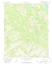
1959 Map of Pebblestone Shut-In
USGS Topo · Published 1975About this map
Mercury mining and rugged coastal range topography define this 1959 survey of the Santa Lucia Mountains. The landscape is marked by numerous extraction sites, including the Almaden Mine and Quien Sabe Mine, centered near the elevated plateaus of Almaden Flats and Marmolejo Flats. These settlements and workings highlight the mid-century industrial presence in this part of San Luis Obispo County before the shift toward conservation. High points like Pine Mtn and the Rocky Butte Lookout provide clear vantage points over a complex network of canyons and watercourses. To the north, the Nacimiento River flows into the Nacimiento Res, while the south is drained by the North Fork San Simeon Creek and South Fork San Simeon Creek. The intricate web of jeep trails and isolated springs suggests a remote working environment for the miners and surveyors of the era.
Find a feature on this map
37 named features on this map. Tap any name to fly to it.
Don’t see what you’re looking for? This feature index may not catch every label — zoom into the map to look around manually.
Map Details
Editions of this 1959 Pebblestone Shut-In Map
4 editions found
Other maps of this area

1919 · Bryson
USGS Topo · 1:62,500

1919 · Bradley
USGS Topo · 1:62,500

1919 · Adelaida
USGS Topo · 1:62,500

1919 · San Simeon
USGS Topo · 1:62,500

1932 · Adelaida
USGS Topo · 1:62,500

1937 · San Simeon
USGS Topo · 1:62,500

1941 · Bradley
USGS Topo · 1:62,500

1941 · Bryson
USGS Topo · 1:62,500

1942 · Adelaida
USGS Topo · 1:62,500

1942 · Bryson
USGS Topo · 1:62,500