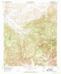
1968 Map of Pechanga
USGS Topo · Published 1970About this map
Pechanga Indian Reservation and Pala Indian Reservation dominate the high-relief landscape of this Southern California survey, which details the rugged boundary between Riverside and San Diego counties. The southern portion of the sheet reveals a significant mining district, particularly for gemstones, with the Tourmaline King Mine, Tourmaline Queen Mine, and Pala Chief Mine clustered near Pala Creek. This concentration of tourmaline and lithium-bearing pegmatite mines reflects the region's unique mineral history.
Find a feature on this map
47 named features on this map. Tap any name to fly to it.
Don’t see what you’re looking for? This feature index may not catch every label — zoom into the map to look around manually.
Map Details
Editions of this 1968 Pechanga Map
3 editions found
Other maps of this area

1901 · Southern California Sheet No. 1
USGS Topo · 1:250,000

1901 · San Jacinto
USGS Topo · 1:125,000

1901 · Elsinore
USGS Topo · 1:125,000

1901 · San Luis Rey
USGS Topo · 1:125,000

1903 · Ramona
USGS Topo · 1:125,000

1904 · Southern California Sheet No. 2
USGS Topo · 1:250,000

1904 · Southern California Sheet No. 1
USGS Topo · 1:250,000

1939 · Palomar Mountain
USGS Topo · 1:62,500

1942 · Temecula
USGS Topo · 1:62,500

1942 · Hemet
USGS Topo · 1:62,500