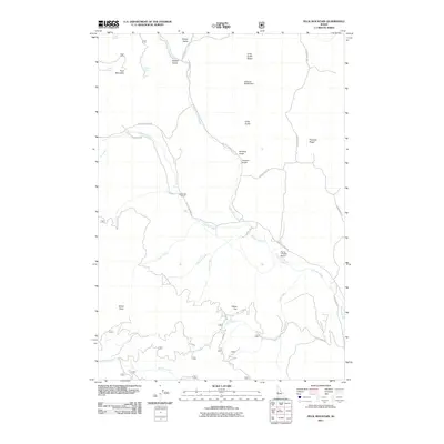
2011 Map of Peck Mountain
USGS Topo · Published 2011About this map
Peck Mountain and its surrounding drainage basins define this portion of Washington County, Idaho. The landscape is characterized by a network of deep gulches and high ridges, where North Hornet Creek and its many tributaries, such as Hanson Creek and Pearl Creek, carve through the terrain. Human presence is concentrated along the primary valley floors and ridge roads. The map highlights local educational history at the Upper Dale School, while modern infrastructure is represented by the Flying Y Ranch Airport and the water management at Ellsworth-Middle Dam. Significant travel routes like Council Cuprum Rd and Cemetery Ln connect these points of interest. Several springs, including Peck Mountain Spring and Grouse Spring, provide vital water sources across the higher elevations of Pleasant Ridge and Long Gulch Ridge.
Find a feature on this map
37 named features on this map. Tap any name to fly to it.
Don’t see what you’re looking for? This feature index may not catch every label — zoom into the map to look around manually.
Map Details
Editions of this 2011 Peck Mountain Map
This is the sole edition of this map. No revisions or reprints were ever made.
Other maps of this area

1911 · Meadows
USGS Topo · 1:125,000

1954 · Council
USGS Topo · 1:62,500

1954 · New Meadows
USGS Topo · 1:62,500

1955 · Baker
USGS Topo · 1:250,000

1957 · Cambridge
USGS Topo · 1:62,500

1957 · Hornet
USGS Topo · 1:62,500

1959 · Baker
USGS Topo · 1:250,000

1980 · McCall
USGS Topo · 1:100,000

1986 · Peck Mountain
USGS Topo · 1:24,000
1986 · Council
USGS Topo · 1:24,000