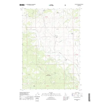
2020 Map of Peck Mountain
USGS Topo · Published 2020About this map
Peck Mtn and the surrounding drainages of Hornet Cr characterize this portion of the Payette National Forest along the border of Adams County. The landscape is defined by a series of prominent ridges and gulches, including Long Gulch Ridge, Robison Gulch, and Traction Gulch, which funnel into the larger creek systems. Historical land use is evidenced by the established road network, such as the Council Cuprum Rd and Upper Dale Rd, which connect the high points of Pyramid Point and Stony Point to the more level areas of Horse Flat. The presence of the Flying Y Ranch Airport near Hanson Cr and Cemetery Ln indicates a pocket of concentrated activity and private property within the largely public forest lands. This 2020 survey documents the modern topography while preserving traditional place names like Skunk Cabbage Flat and Badger Gulch.
Find a feature on this map
47 named features on this map. Tap any name to fly to it.
Don’t see what you’re looking for? This feature index may not catch every label — zoom into the map to look around manually.
Map Details
Editions of this 2020 Peck Mountain Map
This is the sole edition of this map. No revisions or reprints were ever made.
Other maps of this area

1911 · Meadows
USGS Topo · 1:125,000

1954 · Council
USGS Topo · 1:62,500

1954 · New Meadows
USGS Topo · 1:62,500

1955 · Baker
USGS Topo · 1:250,000

1957 · Cambridge
USGS Topo · 1:62,500

1957 · Hornet
USGS Topo · 1:62,500

1959 · Baker
USGS Topo · 1:250,000

1980 · McCall
USGS Topo · 1:100,000

1986 · Peck Mountain
USGS Topo · 1:24,000
1986 · Council
USGS Topo · 1:24,000