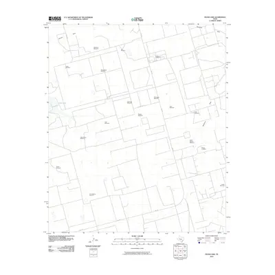
2010 Map of Pecks Lake
USGS Topo · Published 2010About this map
Pecks Lake and the drainage of Johnson Draw define this portion of the Texas landscape, where water management is the primary driver of settlement. The map is notably densely populated by named windmills, reflecting a livestock-driven economy and the necessity of groundwater in this arid region. From the evocatively named Last Chance Windmill and Hi Lonesome Windmill to family-named landmarks like Shackleford Windmill and Weatherd Windmill, these features indicate a sprawling network of ranching infrastructure.
Find a feature on this map
28 named features on this map. Tap any name to fly to it.
Don’t see what you’re looking for? This feature index may not catch every label — zoom into the map to look around manually.
Map Details
Editions of this 2010 Pecks Lake Map
This is the sole edition of this map. No revisions or reprints were ever made.
Other maps of this area

1954 · San Angelo
USGS Topo · 1:250,000

1958 · San Angelo
USGS Topo · 1:250,000

1965 · San Angelo
USGS Topo · 1:250,000

1965 · Dewey Lake
USGS Topo · 1:24,000

1965 · Spraberry
USGS Topo · 1:24,000

1965 · Salt Lake
USGS Topo · 1:24,000

1965 · Pecks Lake
USGS Topo · 1:24,000
1965 · Stephenson Lake
USGS Topo · 1:24,000

1965 · Patterson Lake
USGS Topo · 1:24,000

1967 · Midkiff
USGS Topo · 1:24,000