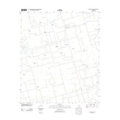
2012 Map of Pecks Lake
USGS Topo · Published 2012About this map
Pecks Lake and the adjacent Pecks Spring sit at the center of this 2012 topographic record of the Permian Basin, where the landscape is defined by the vital infrastructure of water and oil. The map reveals an extensive network of family-named and evocative landmarks that illustrate the ranching heritage and industrial utility of the region, including the Spraberry Gas Plant and numerous wells like Hi Lonesome Windmill, Last Chance Windmill, and Steel Trap Windmill. This grid-heavy terrain is connected by essential thoroughfares such as Ranch Road 1357 and FM 1379, which navigate between sprawling pasture boundaries. The high density of named water points suggests a reliance on groundwater for livestock in an arid environment, providing a detailed look at land usage just before the recent intensification of shale development.
Find a feature on this map
28 named features on this map. Tap any name to fly to it.
Don’t see what you’re looking for? This feature index may not catch every label — zoom into the map to look around manually.
Map Details
Editions of this 2012 Pecks Lake Map
This is the sole edition of this map. No revisions or reprints were ever made.
Other maps of this area

1954 · San Angelo
USGS Topo · 1:250,000

1958 · San Angelo
USGS Topo · 1:250,000

1965 · San Angelo
USGS Topo · 1:250,000

1965 · Dewey Lake
USGS Topo · 1:24,000

1965 · Spraberry
USGS Topo · 1:24,000

1965 · Salt Lake
USGS Topo · 1:24,000

1965 · Pecks Lake
USGS Topo · 1:24,000
1965 · Stephenson Lake
USGS Topo · 1:24,000

1965 · Patterson Lake
USGS Topo · 1:24,000

1967 · Midkiff
USGS Topo · 1:24,000