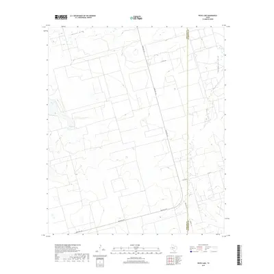
2019 Map of Pecks Lake
USGS Topo · Published 2019About this map
Pecks Lake and the adjacent Pecks Spring anchor this portion of the Permian Basin, where the arid landscape is defined by intermittent drainage patterns. The topographic relief is shaped by Johnson Draw in the north and Pemberton Draw to the east, illustrating the subtle elevation changes characteristic of the High Plains. This 2019 survey captures the modern road network essential to the region's ranching and industrial activity, including Ranch Rd 1379 and Farm Rd 1357. The map also delineates the precise boundary between Midland and Glasscock counties, showing how property lines and rural routes like E Co Rd 230 and E Co Rd 280 conform to the section-line grid of West Texas.
Find a feature on this map
10 named features on this map. Tap any name to fly to it.
Don’t see what you’re looking for? This feature index may not catch every label — zoom into the map to look around manually.
Map Details
Editions of this 2019 Pecks Lake Map
This is the sole edition of this map. No revisions or reprints were ever made.
Other maps of this area

1954 · San Angelo
USGS Topo · 1:250,000

1958 · San Angelo
USGS Topo · 1:250,000

1965 · San Angelo
USGS Topo · 1:250,000

1965 · Dewey Lake
USGS Topo · 1:24,000

1965 · Spraberry
USGS Topo · 1:24,000

1965 · Salt Lake
USGS Topo · 1:24,000

1965 · Pecks Lake
USGS Topo · 1:24,000
1965 · Stephenson Lake
USGS Topo · 1:24,000

1965 · Patterson Lake
USGS Topo · 1:24,000

1967 · Midkiff
USGS Topo · 1:24,000