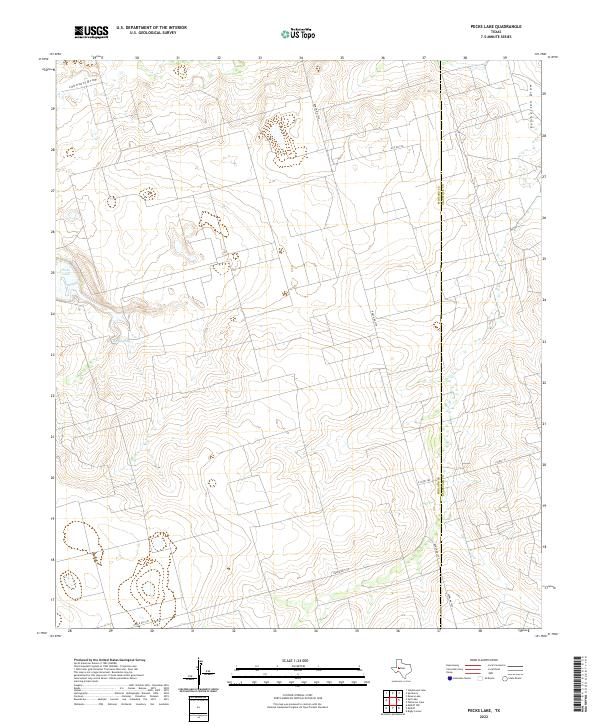
2022 Map of Pecks Lake
USGS Topo · Published 2022About this map
Pecks Lake and the associated Pecks Spring anchor this landscape along the border of Midland and Glasscock counties. The terrain is defined by the ephemeral watercourses of Johnson Draw in the northwest and Pemberton Draw in the northeast, cutting through the high plains of West Texas. This modern survey illustrates the sparse, ranch-oriented infrastructure of the region, where long, straight road segments like Ranch Rd 1379 and Farm Rd 1357 traverse the open country. The intersection of county lines and local access roads such as E Co Rd 230 and Co Rd 110 highlights the systematic division of the land, providing a clear view of current boundary demarcations and drainage patterns in a semi-arid environment.
Find a feature on this map
11 named features on this map. Tap any name to fly to it.
Don’t see what you’re looking for? This feature index may not catch every label — zoom into the map to look around manually.
Map Details
Editions of this 2022 Pecks Lake Map
This is the sole edition of this map. No revisions or reprints were ever made.
Other maps of this area

1954 · San Angelo
USGS Topo · 1:250,000

1958 · San Angelo
USGS Topo · 1:250,000

1965 · San Angelo
USGS Topo · 1:250,000

1965 · Dewey Lake
USGS Topo · 1:24,000

1965 · Spraberry
USGS Topo · 1:24,000

1965 · Salt Lake
USGS Topo · 1:24,000

1965 · Pecks Lake
USGS Topo · 1:24,000
1965 · Stephenson Lake
USGS Topo · 1:24,000

1965 · Patterson Lake
USGS Topo · 1:24,000

1967 · Midkiff
USGS Topo · 1:24,000