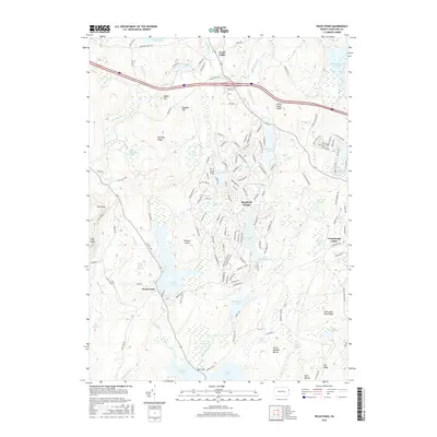
2016 Map of Pecks Pond
USGS Topo · Published 2016About this map
Lords Valley and the residential community of Hemlock Farms anchor this portion of Pike County, where the landscape is defined by a dense network of glacial lakes, ponds, and wetlands. The central waters of Pecks Pond are punctuated by Pinchot Island, while smaller bodies like Elm Lake and McConnell Pond dot the surrounding ridges. To the east, the Conashaugh Lakes development sits near the basin of the Shohola Marsh Reservoir, illustrating the mid-to-late 20th-century transition of this Pocono Plateau region from timberland to a seasonal and residential recreational landscape.
Find a feature on this map
156 named features on this map. Tap any name to fly to it.
Don’t see what you’re looking for? This feature index may not catch every label — zoom into the map to look around manually.
Map Details
Editions of this 2016 Pecks Pond Map
This is the sole edition of this map. No revisions or reprints were ever made.
Other maps of this area

1891 · Wallpack
USGS Topo · 1:62,500

1893 · Wallpack
USGS Topo · 1:62,500

1913 · Milford
USGS Topo · 1:62,500

1915 · Milford
USGS Topo · 1:62,500

1924 · Bushkill
USGS Topo · 1:48,000

1935 · Hawley
USGS Topo · 1:62,500

1938 · Hawley
USGS Topo · 1:62,500

1943 · Bushkill
USGS Topo · 1:62,500

1943 · Lake Maskenozha
USGS Topo · 1:31,680
1943 · Twelvemile Pond
USGS Topo · 1:24,000
Featured Places
- Blooming Grove Township, PA
- Greene Township, PA
- Dingman Township, PA
- Pecks Pond, Porter Township
- Hemlock Farms, Blooming Grove Township