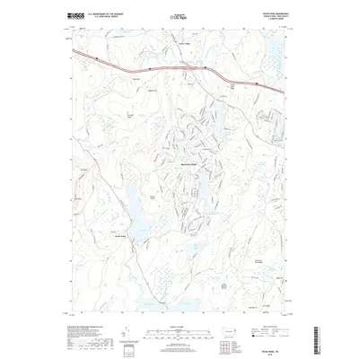
2019 Map of Pecks Pond
USGS Topo · Published 2019About this map
Hemlock Farms serves as a primary residential hub in this part of Pike County, characterized by a dense network of suburban-style roads like Hemlock Farms Rd and Mountain View Dr that contrast with the surrounding wetlands. The landscape is defined by its complex hydrology, where Pecks Pond and Porters Lake anchor a region thick with named swamps, including White Birch Swamp and Inlet Swamp. These water systems, including the Shohola Cr, define the drainage patterns between ridges such as Burleigh Ridge and Little Mud Pond Ridge. High points like High Knob and Madden Hill offer topographical relief in a territory largely devoted to conservation and recreation, as seen in the Lavice Meadow Barren. Smaller settlements like Lords Valley and Pecks Pond appear as key navigation points along Route 402 and 739.
Find a feature on this map
173 named features on this map. Tap any name to fly to it.
Don’t see what you’re looking for? This feature index may not catch every label — zoom into the map to look around manually.
Map Details
Editions of this 2019 Pecks Pond Map
This is the sole edition of this map. No revisions or reprints were ever made.
Other maps of this area

1891 · Wallpack
USGS Topo · 1:62,500

1893 · Wallpack
USGS Topo · 1:62,500

1913 · Milford
USGS Topo · 1:62,500

1915 · Milford
USGS Topo · 1:62,500

1924 · Bushkill
USGS Topo · 1:48,000

1935 · Hawley
USGS Topo · 1:62,500

1938 · Hawley
USGS Topo · 1:62,500

1943 · Bushkill
USGS Topo · 1:62,500

1943 · Lake Maskenozha
USGS Topo · 1:31,680
1943 · Twelvemile Pond
USGS Topo · 1:24,000
Featured Places
- Blooming Grove Township, PA
- Greene Township, PA
- Dingman Township, PA
- Pecks Pond, Porter Township
- Hemlock Farms, Blooming Grove Township