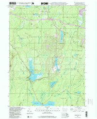
1997 Map of Pecks Pond
USGS Topo · Published 1999About this map
Lords Valley and the expanding residential community of Hemlock Farms serve as the primary hubs in this lake-rich section of Pike County. The landscape is defined by extensive protected acreage, including State Game Lands No 180 and the Delaware State Forest, which together preserve a complex network of wetlands and upland ridges. Water is the dominant feature, ranging from the large recreational waters of Pecks Pond and Lake Giles to specialized terrain like Halsey Meadow Swamp and Little York Swamp.
Find a feature on this map
61 named features on this map. Tap any name to fly to it.
Don’t see what you’re looking for? This feature index may not catch every label — zoom into the map to look around manually.
Map Details
Editions of this 1997 Pecks Pond Map
This is the sole edition of this map. No revisions or reprints were ever made.
Other maps of this area

1891 · Wallpack
USGS Topo · 1:62,500

1893 · Wallpack
USGS Topo · 1:62,500

1913 · Milford
USGS Topo · 1:62,500

1915 · Milford
USGS Topo · 1:62,500

1924 · Bushkill
USGS Topo · 1:48,000

1935 · Hawley
USGS Topo · 1:62,500

1938 · Hawley
USGS Topo · 1:62,500

1943 · Bushkill
USGS Topo · 1:62,500

1943 · Lake Maskenozha
USGS Topo · 1:31,680
1943 · Twelvemile Pond
USGS Topo · 1:24,000
Featured Places
- Blooming Grove Township, PA
- Dingman Township, PA
- Greene Township, PA
- Porter Township, PA
- Lords Valley, Blooming Grove Township