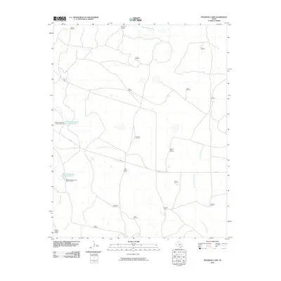
2010 Map of Pedarosa Camp
USGS Topo · Published 2010About this map
Pedarosa Creek and its surrounding drainage basins define this portion of the Texas Panhandle. In this early 21st-century landscape, the distribution of numerous named windmills, such as Partition Windmill, Sinclair Windmill, and Hackberry Windmill, underscores the vital importance of groundwater management for the local ranching economy. The terrain is further shaped by the presence of Martha Houghton Lake Number 1 and Martha Houghton Lake Number 2, both established behind modern dam structures. These water features, alongside Romero Creek and Antelope Spring Creek, provide essential landmarks in a region dominated by open range and limited road infrastructure, primarily centered on FM 767. The eponymous Pedarosa Camp serves as a primary point of human activity, situated near the confluence of local draws and seasonal water sources like Red Spring.
Find a feature on this map
28 named features on this map. Tap any name to fly to it.
Don’t see what you’re looking for? This feature index may not catch every label — zoom into the map to look around manually.
Map Details
Editions of this 2010 Pedarosa Camp Map
This is the sole edition of this map. No revisions or reprints were ever made.
Other maps of this area

1954 · Tucumcari
USGS Topo · 1:250,000

1958 · Tucumcari
USGS Topo · 1:250,000

1971 · Middle Water
USGS Topo · 1:24,000

1971 · Romero SE
USGS Topo · 1:24,000

1971 · Proctor Ranch
USGS Topo · 1:24,000

1971 · Spring Creek Ranch
USGS Topo · 1:24,000

1971 · Many Post Camp
USGS Topo · 1:24,000
1971 · Humdinger Spring
USGS Topo · 1:24,000

1971 · Pedarosa Camp
USGS Topo · 1:24,000

1973 · King SW
USGS Topo · 1:24,000