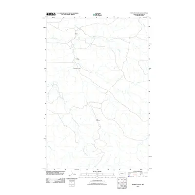
2011 Map of Pedigo Coulee
USGS Topo · Published 2011About this map
Prairie Elk Creek and its numerous branches dominate this drainage basin in McCone County, Montana, as it appeared in the early 21st century. The map reveals a remote ranching landscape defined by erosion and water management, centered around the Slimy Stock Dam. The terrain is deeply incised by multiple coulees, including Pedigo Coulee, Solly Coulee, and Cuttybeck Coulee, which channel seasonal runoff toward the main creek system. Human presence is sparse, represented primarily by the unpaved Thorgaard Rd and a network of tracks that connect isolated stock points. The branching patterns of the Middle Fork Prairie Elk Creek and East Fork Prairie Elk Creek illustrate the natural topography of this high plains environment, where water sources are vital for livestock and local agriculture.
Find a feature on this map
10 named features on this map. Tap any name to fly to it.
Don’t see what you’re looking for? This feature index may not catch every label — zoom into the map to look around manually.
Map Details
Editions of this 2011 Pedigo Coulee Map
This is the sole edition of this map. No revisions or reprints were ever made.
Other maps of this area

1954 · Glendive
USGS Topo · 1:250,000

1957 · Glendive
USGS Topo · 1:250,000

1958 · Glendive
USGS Topo · 1:250,000
1983 · Figure Eight Creek
USGS Topo · 1:24,000

1983 · Haynie Reservoir
USGS Topo · 1:24,000

1983 · Pedigo Coulee
USGS Topo · 1:24,000

1983 · Dailey Spring
USGS Topo · 1:24,000

1983 · North Fork Horse Creek
USGS Topo · 1:24,000

1983 · Hudiburgh Reservoir NW
USGS Topo · 1:24,000
1983 · Sadie Coulee
USGS Topo · 1:24,000