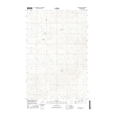
2017 Map of Pedigo Coulee
USGS Topo · Published 2017About this map
Prairie Elk Cr and its numerous tributaries dominate this part of McCone County, Montana, illustrating a deeply dissected drainage system in a high-plains environment. The terrain is defined by a series of named coulees, including Pedigo Coulee, Solly Coulee, and Cuttybeck Coulee, which channel seasonal runoff toward the primary creek beds. The map reveals a complex network of intermittent watercourses such as Flying V Cr and Figure Eight Cr, alongside the branching reaches of Middle Fork Prairie Elk Cr and E Fork Prairie Elk Cr. This landscape remains largely undeveloped, characterized by section lines of the Public Land Survey System and the intricate contouring of the local breaks, which provide critical context for understanding the natural geography of northeastern Montana prior to any significant modern settlement or infrastructure development.
Find a feature on this map
11 named features on this map. Tap any name to fly to it.
Don’t see what you’re looking for? This feature index may not catch every label — zoom into the map to look around manually.
Map Details
Editions of this 2017 Pedigo Coulee Map
This is the sole edition of this map. No revisions or reprints were ever made.
Other maps of this area

1954 · Glendive
USGS Topo · 1:250,000

1957 · Glendive
USGS Topo · 1:250,000

1958 · Glendive
USGS Topo · 1:250,000
1983 · Figure Eight Creek
USGS Topo · 1:24,000

1983 · Haynie Reservoir
USGS Topo · 1:24,000

1983 · Pedigo Coulee
USGS Topo · 1:24,000

1983 · Dailey Spring
USGS Topo · 1:24,000

1983 · North Fork Horse Creek
USGS Topo · 1:24,000

1983 · Hudiburgh Reservoir NW
USGS Topo · 1:24,000
1983 · Sadie Coulee
USGS Topo · 1:24,000