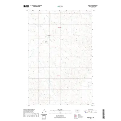
2020 Map of Pedigo Coulee
USGS Topo · Published 2020About this map
Prairie Elk Cr and its numerous tributaries dominate this McCone County landscape, carving a complex network of drainages through the northeastern Montana plains. The topography is defined by deep incisions like Pedigo Coulee and Solly Coulee, which illustrate the erosion patterns characteristic of this region. Named watercourses such as Flying V Cr and Figure Eight Cr provide a rare look at local ranching-era nomenclature preserved on modern surveys. The absence of developed settlements or major highways highlights the remote, open-range nature of the territory within townships t23n r46e and t22n r46e. Cuttybeck Coulee and Middle Fork Prairie Elk Cr further map the intricate watershed that eventually feeds into larger northern systems, offering a clear record of the area's natural drainage before any significant human alteration.
Find a feature on this map
11 named features on this map. Tap any name to fly to it.
Don’t see what you’re looking for? This feature index may not catch every label — zoom into the map to look around manually.
Map Details
Editions of this 2020 Pedigo Coulee Map
This is the sole edition of this map. No revisions or reprints were ever made.
Other maps of this area

1954 · Glendive
USGS Topo · 1:250,000

1957 · Glendive
USGS Topo · 1:250,000

1958 · Glendive
USGS Topo · 1:250,000
1983 · Figure Eight Creek
USGS Topo · 1:24,000

1983 · Haynie Reservoir
USGS Topo · 1:24,000

1983 · Pedigo Coulee
USGS Topo · 1:24,000

1983 · Dailey Spring
USGS Topo · 1:24,000

1983 · North Fork Horse Creek
USGS Topo · 1:24,000

1983 · Hudiburgh Reservoir NW
USGS Topo · 1:24,000
1983 · Sadie Coulee
USGS Topo · 1:24,000