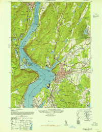
1947 Map of Peekskill
USGS Topo · Published 1947About this map
The Hudson River dominates this mid-century landscape, serving as the central artery between the high elevations of the West Point Military Reservation and the industrial activity of Peekskill. This post-war era shows a region defined by strategic military holdings and substantial institutional architecture, including the Loretta Villa and Mt Florence estates. The industrial and transit infrastructure of the New York Central railroad follows the shoreline, connecting settlements like Verplanck and Buchanan to the larger river economy.
Find a feature on this map
95 named features on this map. Tap any name to fly to it.
Don’t see what you’re looking for? This feature index may not catch every label — zoom into the map to look around manually.
Map Details
Editions of this 1947 Peekskill Map
This is the sole edition of this map. No revisions or reprints were ever made.
Other maps of this area

1891 · Ramapo
USGS Topo · 1:62,500

1892 · West Point
USGS Topo · 1:62,500

1892 · Tarrytown
USGS Topo · 1:62,500

1893 · Tarrytown
USGS Topo · 1:62,500

1893 · Ramapo
USGS Topo · 1:62,500

1894 · West Point
USGS Topo · 1:62,500

1899 · West Point
USGS Topo · 1:62,500

1901 · West Point
USGS Topo · 1:62,500

1902 · Tarrytown
USGS Topo · 1:62,500

1902 · Schunemunk
USGS Topo · 1:62,500