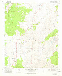
1969 Map of Peeples Valley
USGS Topo · Published 1972About this map
Peeples Valley and its surrounding high-desert terrain are defined by a network of ranching and mining operations in the late 1960s. The landscape is dotted with named windmills like Ferguson Place Windmill, Carter Windmill, and Meadow Windmill, which reflect the essential water infrastructure required for livestock at Hays Ranch. This period of activity is anchored by local institutions such as the Peeples Valley Sch and the Peeples Valley Pioneer Cem, providing a clear view of the area's social and agricultural roots.
Find a feature on this map
44 named features on this map. Tap any name to fly to it.
Don’t see what you’re looking for? This feature index may not catch every label — zoom into the map to look around manually.
Map Details
Editions of this 1969 Peeples Valley Map
This is the sole edition of this map. No revisions or reprints were ever made.
Other maps of this area

1887 · Prescott
USGS Topo · 1:250,000

1892 · Prescott
USGS Topo · 1:250,000

1903 · Congress
USGS Topo · 1:125,000

1904 · Congress
USGS Topo · 1:125,000

1947 · Kirkland
USGS Topo · 1:62,500

1947 · Wagoner
USGS Topo · 1:62,500

1948 · Kirkland
USGS Topo · 1:63,360

1948 · Wagoner
USGS Topo · 1:63,360

1950 · Wagoner
USGS Topo · 1:62,500
1950 · Kirkland
USGS Topo · 1:62,500